Search This Blog

Showing posts with label 3d. Show all posts

12 Oct 2020

thumbnail

PRESS RELEASE — Gexcel presents HERON® MS Twin

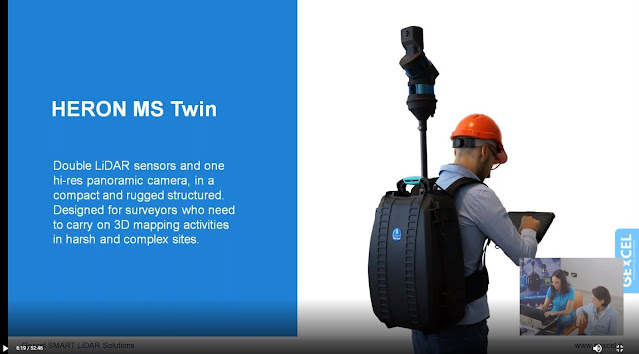
Brescia, Italy, October 7th, 2020_Gexcel is glad to present the new HERON® MS Twin: a double Lidar sensor portable mobile mapping system, equipped with a 5k RGB panoramic camera. Thanks to its advanced hardware+software technology, the users can benefit from a very high-level performance in terms of geometric robustness of 3D models.


Key points of usability:

  • Compact capture head easily mountable on a backpack or various supports like cars, bikes, quads, etc.
  • Light rugged backpack usable both for transportation and surveying.
  • Automatic and on-demand RGB data acquisition.
  • Loop closure and initialization procedure not required.
  • Automatic self-localization on a reference model, when available.
  • Annotation collection during the walk.
  • Usable in every light conditions.
  • Hands-free surveying.
  • Real-time display of panorama images, 3D point cloud, and trajectory on the rugged Control Unit.

Key points of data processing:

  • SLAM post-processing software (HERON® Desktop) included. The automatic advanced processing tools can be also personally set up by the user.
  • New trajectory quality assessment which improves the SLAM drift effects reduction (patented algorithm).
  • Innovative very dense point cloud rendering with multiple colour layers.

HERON MS Twin color layer

  • Static scans usable as trajectory constraints (patented algorithm).
  • Innovative panorama tool to directly export images and 3D data in ReCap® (with Realview® display) and in E57 to easily go to OrbitGT, Edgewise®, FARO® Scene and Scene Webshare Cloud.
  • New “splat rendering” and “eye dome lighting" rendering effect. Features and details are emphasized and well visible.
  • GoBlueprint free tool to share the survey results with final clients or colleagues included.

HERON GoBlueprint

  • Advanced 3D point cloud data analysis software included (Recontructor®).
  • Dedicated tools to navigate 3D models.
  • Real-time change detection.

Thanks to these advanced features, HERON® MS Twin is the perfect system for surveyors who works indoors, outdoors, in underground mines, multi-level buildings, tunnels, cultural heritage sites, forensic procedures, forests, urban areas, harsh and complex areas.

HERON® MS Twin can make the user able to obtain several outputs from collected data: volume computation, excavation progress monitoring, digital archive, construction progress monitoring, floor plans generation for asset management, logistic/traffic management, dilapidation monitoring, scan to BIM, contours and profiles, 3D virtual experience, real-time change detection, as-built generation, security and safety, and much more.

* * *

New HERON MS Twin Live Demo

- watch the webinar recording -

new HERON MS Twin - Webinar
New HERON MS Twin Live demo - Recording

10 Mar 2020

thumbnail

PRESS RELEASE — Gexcel announces RECONSTRUCTOR® 4.2

Brescia, Italy, February 27th, 2020_Gexcel is glad to announce the new release of Reconstructor® that introduces some very interesting improvements for mining, tunnelling, construction, and infrastructure applications thanks to new strategic workflows designed to easily guide customers to final deliverables from the surveying data.


Reconstructor® 4.2 makes a step forward into the processing of large datasets from various 3D sensors and in particular from Mobile Mapping Systems. Reconstructor® 4.2 increases the capability to manage data from tunnels, underground and open-pit mines 3D surveys, thanks to new and improved tools that help users get the result done by a smart process.

Following, a selection of some new key functions introduced in Reconstructor® 4.2:
  • Tunnels, underground and open-pit mines: easy extraction of sequential cross-sections along tunnels axis; measurement of areas and volumes along tunnels; creation of DEM (digital elevation models) starting from 3D point clouds; straight workflow to extract isolines and contours from open-pit mine models and DEMs.
  • Terrain models, buildings and infrastructures: orthophotos can now be used to quickly and efficiently create facades' depth maps. This function can be used also by final clients thanks to the new GoBlueprint free tool. Also, the procedure to extract, display, measure, and move to CAD profiles and cross-sections is now faster and more efficient.
  • Vegetation: colour mapping for point clouds classification and to support the vegetation removal process.
For additional information and demo, click here

5 Jul 2019

thumbnail

EVENT — HERON technology for Museum documentation and Tourism activities

23th July 2019, Italy — Presentazione del lavoro di rilevamento dell'area espositiva Museo Ridola.


HERON Ridola Museum documentation

Si rinnovano i successi e la scelta della tecnologia HERON per lo sviluppo di attività Turistiche e Museali. Questa volta l'interesse arriva da parte del Ministero dei Beni e delle Attività Culturali (MIBAC) e dal polo Museale della Basilicata per progetti dedicati allo sviluppo del territorio. 

Il 23 Luglio 2019 nella storica Sala conferenze del Museo Archologico Nazionale "D.Ridola" Gexcel presenterà il progetto di rilevamento 3D eseguito nel Luglio 2018, dell'intera area espositiva del museo Ridola mediante l'uso di HERON iMMS (Indoor mobile mapping system).

La conferenza è aperta al pubblico ed aprirà le porte alla X International Summer School, organizzata dal Comitato Internazionale Fotogrammetria Architettonica - COIFA e dal Prof. Pietro Grimaldi.

Per maggiori informazioni riguardo all'utilizzo di HERON o per partecipare alla conferenza: marketing@gexcel.it

3 Jun 2019

thumbnail

PRESS RELEASE — HERON®-Verity Integration Introduces Real-Time 3D Mobile Mapping and Construction Verification


HERON - Verity integration


The collaboration between HERON, the latest wearable mobile scanners from Gexcel and Verity construction verification software from ClearEdge3D, significantly advances scan-to-BIM workflows with streamlined data collection and construction QA/QC

Manassas, VA – May 29, 2019 – ClearEdge3D, makers of EdgeWise, Verity, and Rithm for Navisworks software, is pleased to announce a collaboration with Gexcel, makers of HERON® wearable scanners, that was unveiled at the SPAR 3D & AEC NEXT conferences last week in Anaheim, CA. 
The two companies have joined forces to make it even quicker and easier for AEC professionals to conveniently gather as-built data with Gexcel’s HERON wearable laser scanners—and to compare that data against design/fabrication models using ClearEdge3D’s Verity software, allowing 100% verification of installed work in real-time.
"The partnership between ClearEdge3D and Gexcel brings together two globally recognized AEC tech leaders in the 3D world that are committed to making scan-to-BIM workflows more efficient with truly cutting-edge technologies," - Matteo Sgrenzaroli, Gexcel R&D Manager 
“It’s not just a commercial agreement, but a demonstration of our commitment to providing outstanding solutions to our customers and the AEC industry." - Giorgio Vassena, Gexcel CEO
“The HERON scanner is a state-of-the-art 3D mobile scanner powered with cutting edge Simultaneous, Localization And Mapping (SLAM) technology. It features a host of proprietary algorithms to minimize drift and maximize accuracy and speed. We are excited to add it to our growing hardware portfolio.” - Kelly Cone, VP of AEC Industry Strategy at ClearEdge3D. 
This forward-thinking partnership makes it even easier and more convenient for users to find construction mistakes before they become expensive problems. Using real-time visualization of survey results, users can promptly identify out-of-tolerance or inaccurately constructed work. For companies interested in learning more about this collaboration, please contact us at: sales@gexcel.it for more information. 


About ClearEdge3D 
ClearEdge3D is a global technology leader in the Architectural/Engineering/Construction (AEC) industry, offering advanced software solutions that help firms model existing conditions and verify that recently completed work has been constructed correctly. The company’s EdgeWise software dramatically speeds labor-intensive 3D modeling workflows by utilizing advanced automated feature extraction and assistive modeling technology. Its Verity construction verification software compares point cloud data of recently completed work against a design or fabrication model, flagging any out-of-tolerance or poorly installed elements. For more information, please visit http://www.clearedge3d.com. 

About Gexcel 
Gexcel started in 2007 with the mission to turn the latest scientific achievements in the field of geomatics into hi-tech products and services for wide areas of application. Gexcel is a worldwide well-known company capable to transform its know-how in advanced 3D surveying technologies, innovative and productive software and instruments. Gexcel has a rich history spanning more than 10 years of proven fully featured LiDAR and imagery analysis software compatible with all the lidar sensors of the main laser scanner manufacturers. Gexcel is currently present on the market with innovative surveying instruments and it is involved, with several partners, in various projects for the development of innovative solutions based on laser scanner, SLAM and digital photogrammetry.   

26 Feb 2019

thumbnail

PRESS RELEASE — NEW Reconstructor® 4.0

26th February 2019, Italy — Gexcel today announced a new JRC 3D Reconstructor® release with revolutionary changes and improvements that are going to bring interesting and powerful features on the 3D LiDAR data processing software market. 

With the coming release, the well-known software manufactured by Gexcel will change its name in Reconstructor®, a revised brand for a new agile and easily usable application. This newest release 4.0 expands on the most popular software features, providing customers with even more opportunities to get more out of their dataset, save time and build stunning deliverables.

“Since the beginning, Reconstructor® has been a unique tool for a wide range of laser scanning users. This new release is a great step forward in terms of efficiency, usability, and brilliance”, said Matteo Sgrenzaroli, Gexcel’s R&D manager. “There’s a rich basket of new features in this new release, and we can’t wait to see what users will create with it”.


These are some of the key functions added or improved in Reconstructor® 4.0:

  • NEW SOFTWARE MODULARIZATION and LAYOUT to organize the processing tools and customize the software user interface: Reconstructor® 4.0 and its new add-ons are organized in a completely new user interface that provides simple and straightforward access to the software tools.
  • NEW RENDERING ENGINE for a new powerful way to display 3D modelsReconstructor® 4.0 upgrades the 3D visualization engine providing a completely new and more efficient rendering environment for clouds and meshes, unlocking a completely different experience of 3D object visualization. A strong improvement in using the PC graphics resources will let customers handle point clouds up to 200% larger than before.
  • FASTER and MORE EFFICIENT DATA IMPORT and PROCESSING: With Reconstructor® 4.0, the time required for scan importing and filtering is dramatically reduced, saving more than twice the time required by previous releases.
  • LineUp to automatically register CAD and BIM models: LineUp®, the popular and appreciated technology for automatic scans registration, is now fully embedded in Reconstructor® 4.0 main module. The well-known automatic target-less registration tool has been improved to support CAD/BIM and mesh models. 
  • X-RAY ORTHOPHOTOS for easy measuring and drawing: Reconstructor® 4.0 offers a completely new way to extract orthophotos and blueprints enhancing the relevant geometric features of a 3D scanned object. With the innovative GoBluprint free tool, it will be extremely easy to share X-Ray orthophotos among the users' community.

Press HERE to discover the entire changelog for Reconstructor 4.0 


DISCOVER. TRY. ENJOY

RECONSTRUCTOR® 4.0
 FREE DOWNLOAD

For more information or to receive a quotation, contact us: sales@gexcel.it

7 Aug 2018

thumbnail

JRC 3D RECONSTRUCTOR SUCCESS CASE — ARCHAEOLOGICAL MEASUREMENT

CONSERVATION AND RESTORATION Tambomachay complex, Cusco (PERU)

PDF versione italiana

PROJECT DESCRIPTION

KEYWORDS: Cultural Heritage | Archaeology | JRC 3D Reconstructor | LiDAR data

Tambomachay, Peru - Orthophoto of the entire complex - by Restauro SAC - JRC 3D Reconstructor
Fig1_Orthophoto of the masonry complex

In 2017, the CDC Ministry of Peruvian culture commissioned to Restauro S.A.C. the surveying of some Inca historical sites. The Tambomachay is one of these: near to Cusco, this site consists of a series of aqueducts, canals, and waterfalls running through the terraced rocks. It is important to know that, till not long time ago, the measurement of these ancient walls was done by very rudimentary techniques: large sheets of millimetric paper were placed on the wall to manually trace the contours of every single stone and later manually redrawn in the CAD environment. As you can imagine, this workflow is incredibly time/money expensive as it requires months (years!) of work to get results always uncertain, because of drawing errors or missing details (ledge, cavity, pictures, etc.). This the reason that brought the company to operate with a laser scanner technology to face this important work. Thanks to this method it was possible to make a complete survey in less than one working day and extract rocks contour lines measurable with millimetric precision, thanks to the JRC 3D Reconstructor post-processing software.


NEEDS AND GOALS
  • To measure, analyze and document the ancient masonry build by the Inca population.
  • To detect the exact position and verify the deterioration and/or structural failure over time.
  • To intervene with conservation works.

    Tambomachay, Peru - Picture of the site and orthophoto of the masonry - by Restauro SAC - JRC 3D Reconstructor
    Fig.2-3_Orthographic view and the picture of Tambomachay site

    Tambomachay, Peru - High Res orthophoto of the stones - by Restauro SAC - JRC 3D Reconstructor
    Fig.4_High Res orthophoto showing the detail of the stones

    « The processing speediness and accuracy allowed us to generate 2D and 3D data with a precision impossible for the traditional surveying methods. Thanks to JRC 3D Reconstructor, we daily improve the quality and productivity of our job. »
    Wilfredo Torres, Restauro S.A.C. | CEO

    To complete the documentation project and illustrate the real artefact conditions, a CAD drawing with orthophotos was provided.

    RESULTS
    • Detailed technical table with high-resolution orthophotos
    • 3D point cloud model
    • 2D plans and views with millimetric precision

    TECHNOLOGY BENEFITS
    • The speediness of 2D and 3D data extraction
    • The millimetric precision of technical results

    TECHNICAL DETAILS
    • SURVEYING SYSTEM: Faro Focus3D 130x
    • SURVEYING AREA: 2.982 m²
    • SURVEYING TIME: 4 hours
    • PROCESSING SOFTWARE: JRC 3D Reconstructor
    • PROCESSING TIME: 6 hours

      Tambomachay, Peru - CAD plans with CAD plans with photographic view - by Restauro SAC - JRC 3D Reconstructor
      Fig.5_Plan of the scanned site


      ABOUT

      RESTAURO S.A.C. is a Peruvian company that offers a wide range of services related to Cultural Heritage needs. Founded in October 2009, it offers solutions for management, conservation and restoration problems thanks to a national and international experience as well as a selected professional team and high-level technologies.

      9 Jul 2018

      thumbnail

      HERON SUCCESS CASE — UNDERGROUND MINING

      3D SCANNING OF AN OLD MINE Zhejiang Province (China)


      PROJECT DESCRIPTION

      KEYWORDS: Mining | Underground | HERON | 3D Mapping

      The surveying of an underground mine is difficult for two orders of problems: the complicated and dark tunnels environment and the underground depth where GPS or GNSS signal can't be reached.
      The Aurantech company has faced this problem in an old underground mine site, in Zhejiang and thanks to the HERON wearable mobile mapping system the procedure for data collection was not only possible but also efficient.
      After pre-processed the surveying acquisitions and filtered the noise, it has been possible to build the surface model of the tunnel, based on the required parameters, with a global accuracy of 10 cm.
      The data extraction has been made with JRC 3D Reconstructor software. First of all, the data have been aligned via the automatic registration and bundle adjustment software's functions. Then, the cross-sections have been easily generated and volume and surface areas computed on the 3D model. Finally, the 3D model was easily exported to third-party applications using one of the most common data interchange formats.


      Aurantech - The operator with HERON AC-1 during the surveying activities in the underground mine and HERON point cloud model with the path
      Fig 1. The operator with HERON AC-1 during the surveying activities in the underground mine
      Fig 2. HERON point cloud model of the underground mine with the path
      Aurantech - HERON 3D mesh model of the underground mine
      Fig 3. HERON 3D mesh model


      « What we had to do was just to set up some control points using a total station and then simply walk with HERON. Software and hardware made the work easier and supplied us with a complete solution. HERON is a reliable, simple and high-performance 3D solution »
      Sherry Wang
      AURANTECH | Commercial Manager


      NEEDS AND GOALS

      • Generate a precise map of an old tunnel where tripod laser scanners or GPS cannot be used.
      • Build a measurable 3D model of the underground mine starting from the 3D point cloud.


      RESULTS

      • 3D point cloud model
      • Depth calculation
      • Area calculation
      • Cross-sections
      • Volume calculation


        Aurantech - CAD environment: cross sections of the HERON point cloud model of the underground mine
        Fig 4. CAD environment: cross-sections of the HERON point cloud model


        HERON AC-1 MAIN BENEFITS

        • Work without GPS or GNSS sensors
        • The precision of final results
        • Management of wide and different data


        TECHNICAL DETAILS

        • SURVEYING SYSTEM: HERON AC-1 and total station
        • SURVEYING AREA: 250,000 sqm abandoned mine
        • SURVEYING TIME: 6 hours
        • PROCESSING SOFTWARE: HERON Desktop and JRC 3D Reconstructor
        • PROCESSING TIME: 18 hours


        ABOUT

        Aurantech | www.aurantech.com
        Aurantech is a high-tech company situated in Shangai (China) featured to provide complete 3D solutions; highly experienced in 3D project services from 3D data collection, 3D data processing to the 3D information management system for final customers.


        17 May 2018

        thumbnail

        EVENT — Gexcel and HERON at GEO Business Show 2018

        HERON® AC-1, the innovative Wearable Mobile Mapping System from Gexcel, is having a significant success worldwide on innovative BIM-check projects. Several customers are using the HERON® change detection feature to highlight differences between the reality and the BIM model: everything in real time.

        Real-time and effective scan to BIM quality check services on huge sites, such as airports, industrial plants, and construction yards are now possible!


        HERON® can survey complex environments without any external positioning system and is capable to highlight in real-time possible geometrical changes between different surveying sessions. Moreover, HERON® works as a localization system using either a former survey or a CAD model as reference frame.

        Thanks to these unique features, HERON® has been adopted by international institutions and large companies involved in the nuclear power plant and advanced industrial projects.


        >> Visit Us on Stand L15 at GEO Business (22-23 May, London) <<


        19 Apr 2018

        thumbnail

        ELISIR project: eco-seismic building regeneration 4.0

        Gexcel will provide its own technologies in 3D mapping, fast 3D digitalization, and BIM model update within the ELISIR project. These technologies are essential to drastically reduce costs and times of surveying activities and to assess in real-time the as-built conditions of a building.

        ELISIR stands for Energy, Life Styled & Seismic Innovation for Regenerated Buildings and it aims at exploiting the potential of digitization in order to create a very personalized product-service to be offered on the market of the existing building heritage focused on seismic improvement and energy efficiency in a "smart living" way, developing a real "Built in Italy". The research project has been launched last November with a research call funded by the Lombardy Region and will end in May 2019.

        gexcel-heron-elisir-progetto

        Gexcel participates in the project, along with other important partners, using the HERON technology for the rapid survey of buildings, for the as-built data acquisition in the form of a point cloud, and will further develop the product adding the possibility of collecting camera data. Schneider will contribute by developing appropriate sensors for energy analysis, a platform for collecting, storing and processing data and validating them. Valsir will undertake the development of hydraulic connections leveraged by sensors, to monitor all the water consumption of the various users. H&D will craft appropriate financial products to provide "the business model and a brand capable of spreading and introducing innovation in the supply chain" with possible "consequences on foreign markets that will be investigated together with the partners involved". Delta Phoenix will fine-tune the energy seismic plaster. The development of smart windows will be taken care by Italserramenti, which will experiment products with a high degree of automation and intelligence, able to adapt to users' needs and independently manage environmental comfort.

        The concept of the project was born at the DICATAM headquarters in the University of Brescia, on the initiative of Angelo Ciribini, one of the leading experts in Building Information Modeling (BIM) and digitization in construction. The second university involved is the Milan Polytechnic, with the Abc department - Architecture, Engineering and the built environment, and in particular with the operating units "Building envelope engineering group" and "Sustainable building process management group". Find more...

        6 Apr 2018

        thumbnail

        SUCCESS CASE — CONSERVATION, RECOVERY AND RESTORATION OF HISTORICAL BUILDINGS

        The ancient complex "Convent and Prison of S. Domenico buildings" San Gimignano, Siena (Italy)

        PDF versione italiana


        PROJECT DESCRIPTION

        KEYWORDS: Classification Mapping | JRC 3D Reconstructor | 3D Laser Scanner | Heritage | Architectural

        Assignment carried out in 2016 and 2017 for the underground part, commissioned by the Public Authority of San Gimignano (Siena) to the "RTP Borromini" group, a multidisciplinary professional team composed of specialists in architecture, engineering, restoration, and archaeology. The STUDIO ASSOCIATO PERIGEO was involved in the topographic and laser scanners survey. The complicated geometries detected with the 3D laser scanner, together with the accurate topographic survey, were then used for all the subsequent phases of detail analysis and output of a unique georeferenced system. Thanks to the data processing software JRC 3D Reconstructor, it was possible to collect and share 3D outputs from laser scanner scans and an in-depth evaluation of underground constructions of historical and anthropological interest.

        studio associato perigeo, jrc 3d reconstructor, complex "convent & prison of S. Domenico buildings" S.Gimignano, Siena (IT)
        Fig.1_Surveying activity
        studio associato perigeo, jrc 3d reconstructor, complex "convent & prison of S. Domenico buildings" S.Gimignano, Siena (IT)
        Fig.2_3D coloured point cloud model: a global view of the complex with caves


        « Thanks to the Gexcel software, I could complete an important laser scanner survey with high accuracy and quality, very demanding for its features and dimension »

        Roberto Pierini
        STUDIO ASSOCIATO PERIGEO | Senior Surveyor


        NEEDS AND GOALS

        • An integrated geometric dataset for multidisciplinary technical activity aimed at reconstructing the cognitive framework.
        • Essential geometric data for subsequent conservation, recovery, and enhancement of the historical compendium. 
        • Accurate 3D laser scanner survey of façades, cloister, chapel and underground cavities.
        • Topographic support.


        RESULTS

        • Detailed technical table
        • Plans, sections, elevations, high-resolution orthophotos and photo plans
        • 3D point cloud model
        • 3D model flythrough movies
        • Mines and tunnels 3D metric survey

        studio associato perigeo, jrc 3d reconstructor, complex "convent & prison of S. Domenico buildings" S.Gimignano, Siena (IT)
        Fig.3_Hypogeal tunnels with altimetric colouring
        studio associato perigeo, jrc 3d reconstructor, complex "convent & prison of S. Domenico buildings" S.Gimignano, Siena (IT)
        Fig.4_Vertical section and orthographic view of the cave interior
        studio associato perigeo, jrc 3d reconstructor, complex "convent & prison of S. Domenico buildings" S.Gimignano, Siena (IT)
        Fig.5_3D coloured model | Global view and internal detail


        JRC 3D RECONSTRUCTOR MAIN BENEFITS

        • Easy management of a big dataset
        • Millimetre precision of the results
        • Compatibility of different laser scanners
        • Fast third-party software connection


        TECHNICAL DETAILS

        • SURVEYING SYSTEM: Laser scanner Faro Focus3D X130 - Total station Leica TS06
        • SURVEYING AREA: Area: 8.700 m² approximately - Prospects: 15.000 m² approximately
        • SURVEYING TIME: Topographic and laser scanner: 6 days (2 operators)
        • PROCESSING SOFTWARE: JRC 3D Reconstructor - PointR3
        • PROCESSING TIME: Laser models: 30 days (1 operator)


        studio associato perigeo, jrc 3d reconstructor, complex "convent & prison of S. Domenico buildings" S.Gimignano, Siena (IT)
        Fig.6_Final delivery | Orthophoto inserted into the 3D point cloud

        studio associato perigeo, jrc 3d reconstructor, complex "convent & prison of S. Domenico buildings" S.Gimignano, Siena (IT)
        Fig.7_Final delivery | 3D coloured models


        ABOUT

        STUDIO ASSOCIATO PERIGEO | www.studioperigeo.it
        The STUDIO ASSOCIATO PERIGEO, by Roberto Pierini and Valentina Tinti, features more than 30 years of experience in topographic, architectural, building and inventory surveys; for public associations and administrations as for individuals, businesses, or professionals in the fields of renovation and design, where it is important to create functional synergies to provide adequate metric datasets necessary for consistent and sound tasks performance.


        6 Feb 2018

        thumbnail

        PRESS RELEASE — GEXCEL and 3DFLOW: a stronger partnership to integrate LiDAR and Photogrammetric technologies

        6th February, 2018, Italy — Gexcel is proud to announce the latest strengthening of the partnership with 3DFlow, finalized to improve the integration between their specific sectors: LiDAR and Photogrammetry.


        The task to provide to the market outstanding solutions and products capable to integrate LiDAR and Digital Photogrammetry is one of the main strategic goal of both companies, Gexcel and 3DFlow.

        The partnership between Gexcel and 3DFlow started in 2012, when an innovative software for digital Photogrammetry was commonly customized and named PixR3 to satisfy the needs of Gexcel's customers.

        In these years the competence and the diffusion of Gexcel's products in the global LiDAR market are dramatically grown and the products like JRC 3D Reconstructor® (software for LiDAR data management) and HERON® (SLAM based mapping wearable system) are became estimated and well known products worldwide.

        On the other hand, also the worldwide presence and high competence of 3DFlow products and services in the digital photogrammetric field are exponentially grown. For this reason both partners have commonly decided to be more focused on their main technology competence, not forgetting the strategic importance of the integration between LiDAR and Digital Photogrammetry products.
           
        The strengthen partnership will allow Gexcel to full benefit of the 3DFlow technology in a more integrated and cross way. Gexcel portfolio will be now enriched with all the 3DF Zephyr® software solutions, perfectly integrated with JRC 3D Reconstructor® LiDAR software, to provide ever more complete solutions to users and final clients.


        Follow Gexcel on gexcel.it/software/3df-zephyr to learn more on the software integration and 3DF Zephyr® software.


        About Gexcel

        Gexcel has a rich history spanning more than 10 years of proven fully featured LiDAR and imagery analysis software like the well-known JRC 3D Reconstructor®. Gexcel’s software are compatible with the LiDAR sensors of the main laser scanner manufactures such as Faro, Geomax, Riegl, Stonex, Surestar, Teledyne-Optech, Topcon, Trimble, Velodyne and Z+F. Gexcel is currently present on the market with innovative surveying systems (HERON® and OPMMS®) and it is involved, with several partners, in various projects for the development of innovative solutions based on laser scanner, SLAM and digital photogrammetry. Gexcel was established in 2007 from the academic know-how of the University of Brescia and the applied research achievements of the European Joint Research Centre (JRC), located in Ispra (Italy).

        About 3DFlow
        3Dflow is a completely private held consulting company and software house operating in the field of Computer Vision and Image Processing. It was established in 2011 as a spin-off of the University of Verona and in 2012 it became a spin-off of the University of Udine. 3Dflow is a dynamic, innovative company committed to providing cutting-edge solutions and software components involving Photogrammetry, 3D modeling of reality, 3D processing and 3D visual effects. Its customers ranges from small local industries to worldwide leading entertainment companies.

        --------------


        Published on:

        - https://www.geoconnexion.com/news/a-partnership-to-integrate-lidar-and-photogrammetric-technologies
        - http://www.amerisurv.com/content/view/16560/
        - http://www.lidarmag.com/content/view/12650/