Search This Blog

12 Jan 2023

thumbnail

PRESS RELEASE — GEXCEL HERON 3D Mobile Mapping: Improvements in Accuracy and Usability

 Gexcel HERON software improvements


Brescia, Italy, January 12th, 2023

The recently released versions of HERON processing software(s) make HERON 3D mapping projects more accurate, effective and usable thanks to important improvements in the usage of ground control points, in the change detection workflow, and for the cloud-sharing process.
 

CONSTRAINT TOOL


Several ways to constrain and geo-reference HERON trajectories.
Ground Control Points (GCPs)
- Measuring GCPs directly in the field by using HERON and a calibrated pole or
- Identifying CGPs on the HERON point cloud.
GCPs local coordinates are automatically paired with the related global coordinates.
Point Clouds and Scans
Static scans or portions of 3D point clouds previously acquired also with different sensors (UAV, mobile scanners, mapping systems, photogrammetry) can be used as constraints as well.

Constraint procedures play a crucial role to improve the quality of the final trajectory!

CHANGE DETECTION MAPS

HERON - Change Detection Map


1. Use a point cloud or BIM model as a reference map.
2. Let HERON self-locate with respect to the reference.
3. Produce a survey aligned with the reference map.
4. Detect changes that occurred in the time.
5. Automatically get the change detection map for further editing.

CLOUD SHARING

Mobile mapping is dramatically speeding up the process of capturing 3D and image data. This should be matched by the speed of project delivery and online procedures.


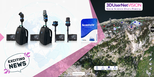
To increase Site to Sight of data efficiency, GEXCEL customers can now link up with 3DUserNet to get a special free annual subscription to the VISION platform with a direct workflow from Reconstructor to 3DUserNetVISION. This will enable users to deliver more efficiently for their customers – with the opportunity to upgrade to a full subscription at a substantial discount at any time.

For additional information: sales@gexcel.it


11 Jan 2023

thumbnail

CHANGELOG - Reconstructor 4.4


Reconstructor 4.4 is out now!

The full changelog is the following:


Added
  • added the "Project data purge" command to remove unused data inside the project folder.
  • added option to remove only groups or groups and contained items when deleting groups from the project view
  • added the option to create UCS from two points and a fixed vertical in the UCS creator window.
  • when exporting models in native formats, added the option to export them in current UCS coordinates. 
  • added the command compute 3D reflectance color layer in the Cloud coloring toolbox and Photo & Color contextual menu. 
  • added a button for computing the histogram in the Inspection dialogue. 
  • added importing annotations from a CSV file with the fields: annotation name; X,Y,Z; comment; hyperlink.
  • added functions to remove big triangles and trim mesh borders in the mesh editor.
  • added support for different rotation ordering conventions in the Euler angles dialogue.
  • added a generic export command for 3DUserNetVISION to export either point clouds (LAS format) or meshes (OBJ format).
  • [HERON add-on] added a tool in the HERON Survey Editor to convert the currently selected frame of a streaming camera to a standalone single-shot camera
  • [HERON add-on] added hide-back facing points option to 3D panorama exporter. 


Changed
  • restored export E57 data in column-major order, since it is the most commonly used memory layout.
  • changed the way in which spherical and cylindrical cameras are drawn in 3D scenes, making the consistent with orthographic and perspective cameras.
  • changed the "UCS coordinates" option behaviour in the adjust pose window so that applying a rotation to the selected item will rotate it around UCS centre coordinates.
  •  improved the responsiveness of the Quick Profile and Tunnel Survey tools when loading existing surveys associated with several models.
  • upgraded the LAS exporter using the latest format version 1.4.
  •  improved the appearance of the point list import dialogue, making it more obvious that the preview is limited to five lines.
  • improved the layout of the camera calibration dialogue to better adapt to screens of different sizes.
  • updated 3D mesh algorithm: mesh generation is now faster and does not require the writing of temporary data to disk.
  • updated Chinese language translation.
  •  improved the Point List Row Format dialogue supporting also the simplest case of text files containing the fields: x,y,z.
  •  improved update 3D scene and the point cloud color list when computing a new color layer from the color map commands.
  • moved "Color with Ambient light", "Add color layer from image" and "Merge and split color layer" commands from the Color Mapping dialogue to the Cloud Coloring toolbox and Photo & Color contextual menu.
  • improved the project item drag and drop functionality, providing better visual feedback on whether an item can be dropped into a particular group within the project.
  • reduced approximation error when computing volume from the plane of a mesh delimited with a polyline.
  •  [HERON add-on] overhauled the Prepare reference map tool with improved user experience and new functionalities to automatically annotate trajectory points when generating from a HERON point cloud.
  • [HERON add-on] reduced the minimum voxel size when importing HERON data to 1mm.
  •  [HERON add-on] updated instruction texts to 3DUserNetVISION and OrbitGT exporters.
  •  [HERON add-on] exported the current rendered point cloud's color layer in HERON third-party exporters.
  •  [HERON add-on] split statistical outliers (SOR), outliers and hide black points steps from sensor noise attenuation filter, in HERON data enhancements import.


Fixed
  • fixed application crash when importing IFC files.
  • fixed the update issue that was rendering geometric shapes with wrong parameters.
  • fixed the cross-sections' computation with geo-referenced data.
  • fixed a failure to import data from another Reconstructor project containing HERON surveys
  • fixed the number of returns detection for LAS data.
  • fixed the fine registration PDF reports not opened.
  • fixed export invalid and noisy coordinates in LAZ export.
  • fixed export truncated coordinates value to textual formats.
  • fixed a bug that prevents computing the area of the mesh.
  • fixed a crash while changing the number of bins in the inspection recipe window. 
  • fixed crash when reading corrupted data from disk.
  • fixed 2D view was not hiding deleted points.
  • fixed crash when importing PTG files with no color data.
  • fixed broken texture mapping functionality.
  • fixed occasional crashes and glitches when loading two models side by side in manual registration.
  • fixed an unintended reset button click by hitting the Enter key in Color Mapping dialogue.
  • fixed the Color Mapping dialogue's excessive size when the min and max labels have many number digits.
  • fixed crash in Color Mapping dialogue computing the histogram using less than three bins.
  • fixed crash while computing the color layer's minimum and maximum values.
  • fixed computation of minimum and maximum values skipping the not-a-number values.
  • fixed a crash due to an invalid histogram in Color Mapping dialogue.
  • fixed a crash caused by a division by zero when painting the histogram in Color Mapping and Inspection dialogues.
  • fixed the Quick Profile tool showing a checkmark even if no profile plane was selected in some rare cases.
  • fixed a bug in the out-of-range field of the PDF report of the inspection.
  • fixed compatibility with systems that use a non-English locale or that have a customized decimal or thousands separator in the Windows regional settings.
  • fixed some issues when using non-metric units of measurement.
  • fixed the formatting of several warning messages that had lost their yellow background.
  • fixed a crash with AMD Radeon GPUs when EDL is enabled in the light settings.
  • [HERON add-on] fixed a failure to import data from another Reconstructor project containing HERON surveys.
  • [HERON add-on] fixed number of returns detection for LAS data.
  • [HERON add-on] fixed the rendering of the Recompute Origin preview from the Send to HERON Desktop tool when the cloud's orientation doesn't match the UCS.
  • [HERON add-on] fixed the rendering of HERON Surveys and their blueprint layers.
  • [HERON add-on] fixed a crash when using certain commands with a heterogeneous multi-selection of items.
  • [HERON add-on] fixed a crash when models with targets are children of another model.
  • [HERON add-on] fixed a crash when creating a reference map from a cloud that doesn't contain a Reflectance layer.
  • [HERON add-on] fixed a crash when importing HERON data from a project where some resources were deleted.
  • [HERON add-on] fixed an issue that made the sub-items of a HERON Survey draggable out of it, resulting in a corrupted project.
  • [HERON add-on] fixed a crash when using point classification functions in projects created through HERON Desktop.
  • [HERON add-on] fixed the formatting of several warning messages that had lost their yellow background.
  • [HERON add-on] fixed an error when computing the spherical coordinates of the HERON 3D panoramas in E57 format.
  • [HERON add-on] fixed a bug that prevents the export of 3D Panoramas when selecting single-shot and streaming cameras.
  • [HERON add-on] fixed a crash if the HERON project file doesn't contain the required metadata for trajectory items.

Removed

  • removed E57 format selection prompt: cloud structure is now automatically detected.
  • removed 3bc auxiliary data from point clouds. Color mapping is now computed on the fly using GPU.


24 Nov 2021

thumbnail

PRESS RELEASE — GEXCEL and 3DUserNetVISION combine to offer speed and efficiency in mobile mapping

HERON & Reconstructor data sharing by 3DUserNetVISION

Brescia, Italy, November 24th, 2021

«We are glad to announce the collaboration with 3DUserNetVISION because this means we can provide our HERON and Reconstructor clients with 3D point clouds and image data sharing services for mapping projects». Giorgia Rossi, International Sales Manager of Gexcel

All data acquired with HERON and all 3D models managed with Reconstructor can now be directly uploaded to 3DUserNetVISION and shared in the cloud. And thanks to this partnership, all existing and new Gexcel customers can get the platform at a special rate.

Getting data quickly from scanner to user is more and more crucial in today's demanding world of survey, where several partners need to easily access 3D models to speed up decision-making processes. Heron and Reconstructor give you high-quality outputs quickly and accurately, VISION makes them worldwide and immediately accessible.

Uploading point clouds, meshes and images directly to 3DUserNetVISION from Reconstructor, gives immediate and secure access to project data for a team, for viewing and collaboration on deliverables. And it works on all your devices, so you have your data with you at all times.

Gexcel customers are able to obtain a 25% discount on their first full year subscription of any VISION modules and data packs. REQUIRE YOUR DISCOUNT >> CLICK HERE

27 May 2021

thumbnail

HERON SUCCESS CASE — VOLUMES OF SCRAP METAL STOCKPILES

THE PRODUCTION PROCESS OPTIMIZATION IN A STEEL PLANT 

Feralpi Group – Lonato, Brescia (IT)

PDF versione italiana

PROJECT DESCRIPTION

KEYWORDS: Steel plants | Volumes computation | Stockpiles | Heron | 3D Mapping


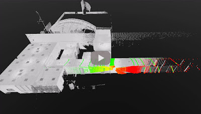
HERON portable mobile mapping - stockpile volume computation - Feralpi Group

HERON MS TWIN-metal stockpile 3D mapping


Feralpi has set itself the goal of introducing advanced systems to monitor and verify the flows of raw materials and by-products of the steel mill, in order to optimize its production process.
Feralpi has chosen HERON technology because it fits their different needs. On one hand, the need to periodically obtain the volumes of the scrap stockpiles stored on a large area of the plant; on the other hand, the need for a high speed of scanning and results delivery, ensuring the required accuracy.
The project involves a monthly survey of the material stockpiles with HERON portable laser scanner technology.
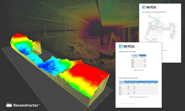
During the 3D modelling phase, the stockpiles are isolated from the structural elements of the plant to define their volume.
The day after the measurement, a technical report with the measurements of the overall volumes is provided to Feralpi.
Thanks to this technological improvement, Feralpi is experimenting with a more efficient approach to the management of raw materials at low costs.


NEEDS AND GOALS
  • To monitor and verify the flows of raw materials and by-products of steelworks by using advanced systems.
  • To optimize the production process.


« Thanks to HERON technology we are able to map our material parks in a short time and with high precision. »


Gianpaolo Foglio |  
Head of Steelworks at Feralpi Siderurgica S.p.A.


HERON-Reconstructor scrap metal stockpile volume computation - Feralpi Group


HERON MAIN BENEFITS

  • Fast and simple mapping procedures easy to reproduce
  • Fast mapping of large stockpiles
  • No impact on daily production activities
  • Fast volumes computation
  • Centimetre level accuracy
  • Costs reduction
  • Production efficiency improvement
  • Usable for mapping different type of sites (steel plants as well as buildings)

              RESULTS

              • Stockpiles 3D modelling
              • Volumes computation

              TECHNICAL DETAILS

              • SURVEYING SYSTEM: HERON portable mapping system
              • SURVEYING TIME: about 1 h for 18.300 m2
              • PROCESSING SOFTWARE: HERON Desktop - Reconstructor
              • DATA PROCESSING TIME: half working day


              To carry out the work, Feralpi Group makes use of the HERON rental service with the operator, data processing and delivery of results.


              ABOUT

              The Feralpi Group is one of Europe's leading steel manufacturers. It offers innovative and sustainable answers to the steel supply chains thanks to a diversified and vertical business.

              13 May 2021

              thumbnail

              CHANGELOG - Reconstructor 4.3.1

              Reconstructor 4.3.1 is out now!

              The full changelog is the following:

              Added
              • added "hide back facing points" and "splat rendering" options to virtual scan dialogue in order to create more dense and precise grids or orthophotos
              • added "the Min number of ICP iteration" parameter in ICP dialogue
              Changed
              • HERON 3D panorama export does not modify the rendering settings after the export process
              Fixed
              • fixed loss of coordinates precision when parsing large coordinates in text format
              • fixed point items sometimes being rendered with huge scale
              • fixed that orthophoto image plane is no more rendered in other orthophotos
              • fixed volume from plane constrained by a polyline, it was returning zero volume in some cases
              • fixed orthophoto measures not being displayed in 3D view
              • fixed wrong approximation of coordinate values in the property browser
              • fixed export poses to ReCap format for unstructured point clouds
              • fixed colour mapping dialogue min/max reset buttons providing wrong values
              • fixed precision error during the calculation of out of range points in colour mapping dialogue
              • fixed colouring inspection layer when changing the units of measure from International unit to Imperial or US ones
              • improved reliability of the crash reporter tool; a log file is automatically sent to Gexcel when Reconstructor fails

              18 Mar 2021

              thumbnail

              CHANGELOG - Reconstructor 4.3

              Reconstructor 4.3 is out now!

              The full changelog is the following:

              Added

              New Rendering

              • added point cloud splat rendering in the application options dialogue
              • added hide back-facing points option in the light settings dialogue
              • added view camera cut planes auto adjustment option, available in the view parameters dialogue
              • added new "Eye dome lighting" rendering effect, available in the light settings dialogue
              • added view camera cut planes auto adjustment option, available in the view parameters dialogue

              [HERON Add-on] Panorama Tool

              • added experimental depth filling preset in the virtual scan dialogue
              • added command to export HERON survey cameras (single shot, streaming or both) as a collection of virtual scans in .e57 or in ReCap .rcp project format)
              • added an option to export the colour for invalid points in .e57 grid point clouds
              • added support for exporting and importing the points' normals (inclination layer) in the .e57 grid or unstructured point clouds

              [HERON Add-on] Dedicated HERON Import & Filtering

              • added "pre-process survey" to HERON toolbar: this command runs a set of algorithms to improve HERON surveys data quality
              • added "better-noise-remover" in the pre-processing dialogue
              • added "data enhancements" options in the import HERON data dialogue. Options: sensor noise attenuation filter, normals computation, enhanced reflectance computation
              • added an option to voxelized the HERON clouds while importing them
              • added an option to keep the Curvature and Confidence layer when using the Restore raw data function
              • added camera calibration checkbox in the HERON import dialogue used to improve the image to point cloud alignment
              • added an option to keep the Curvature and Confidence layer when using the Restore raw data function

              [HERON Add-on] Improved Bluprint Navigator

              • added the "default view" button in the mesh editor dialogue

              Inspection

              • cloud to cloud inspection to compare two point clouds together


              Changed

              Import/Export

              • improved compatibility of the .ptx importer with data having a non-standard grid layout
              • improved compatibility of the .e57 importer with data having a non-standard grid layout
              • improved the overall ReCap exporter by checking the validity of the destination folder and by improving the final information dialogue with the export results. It also fixes a bug preventing the reflectance colour layer to be correctly exported
              • [HERON Add-on] improved support for HERON clouds exported without voxelization, now importing all the colour layers
              • [HERON Add-on] enhanced HERON global optimization Reflectance layer by replacing the grayscale with an RGB colour map (similar to the Leica "Polarized reflectance")

              Filtering

              • improved the accuracy of the point radius extraction preprocessing step
              • [HERON Add-on] changed the name of the Confidence layer imported from HERON data to HERON_Confidence, to avoid conflicts with the Confidence calculated within Reconstructor

              Miscellaneous

              • changed video codec selection
              • improved the application “about” dialogue
              • [HERON Add-on] dialogue when creating a movie from a trajectory flythrough. The application now uses native platform encoders to create a video

              Fixed

              • [HERON Add-on] fixed a missing Confidence layer from imported HERON clouds
              • fixed matching of origin constraints from point list when running automatic pre-registration
              • fixed crash when automatic preregistration with constrained origin through LineUp wizard and loading more origins that the scans to register
              • fixed importing FARO colour of a detailed scan
              • fixed importing FARO with subsampling that causes a wrong view inside the 2D windows
              • fixed an issue that caused the points from certain clouds to be missing from the generated X-Ray Orthophotos.
              • fixed inspection in case of georeferenced models
              • fixed "Import Reconstructor project" command was not reading correctly projects generated with older Reconstructor versions
              • fixed import and export of mesh files from and to files containing Unicode characters
              • fixed "hide black points" command was restoring manually deleted points
              • fixed a crash when importing certain .e57 files with normals
              • fixed a loss of precision when importing .e57 files with large coordinates, causing artefacts in the imported point clouds
              • fixed a misleading error message when recreating an X-Ray Orthophoto from the Orthophoto Viewer
              • fixed an error when exporting .e57 files with non-ASCII characters in their filename
              • fixed numerical issue when computing cut & fill volumes
              • fixed crash when computing cut & fill volumes with the option "save planes corresponding to altitudes in project"
              • fixed the view direction when selecting a single-shot camera in the Blueprint Navigator
              • fixed a failure to import cameras when importing .e57 files
              • fixed the export to .e57 of cameras in the .tiff format, such as the ones calibrated on a model
              • fixed the focal length of perspective cameras exported into a .e57 file or imported from a .e57 file
              • fixed a crash when closing the HERON Survey Editor recipe while the layer editor is open
              • fixed the destination group when importing a .e57 file with multiple point clouds
              • fixed a failure to import .e57 files with non-ASCII characters in their filename


              12 Oct 2020

              thumbnail

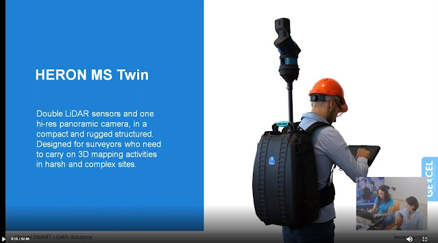
              PRESS RELEASE — Gexcel presents HERON® MS Twin

              Brescia, Italy, October 7th, 2020_Gexcel is glad to present the new HERON® MS Twin: a double Lidar sensor portable mobile mapping system, equipped with a 5k RGB panoramic camera. Thanks to its advanced hardware+software technology, the users can benefit from a very high-level performance in terms of geometric robustness of 3D models.


              Key points of usability:

              • Compact capture head easily mountable on a backpack or various supports like cars, bikes, quads, etc.
              • Light rugged backpack usable both for transportation and surveying.
              • Automatic and on-demand RGB data acquisition.
              • Loop closure and initialization procedure not required.
              • Automatic self-localization on a reference model, when available.
              • Annotation collection during the walk.
              • Usable in every light conditions.
              • Hands-free surveying.
              • Real-time display of panorama images, 3D point cloud, and trajectory on the rugged Control Unit.

              Key points of data processing:

              • SLAM post-processing software (HERON® Desktop) included. The automatic advanced processing tools can be also personally set up by the user.
              • New trajectory quality assessment which improves the SLAM drift effects reduction (patented algorithm).
              • Innovative very dense point cloud rendering with multiple colour layers.

              HERON MS Twin color layer

              • Static scans usable as trajectory constraints (patented algorithm).
              • Innovative panorama tool to directly export images and 3D data in ReCap® (with Realview® display) and in E57 to easily go to OrbitGT, Edgewise®, FARO® Scene and Scene Webshare Cloud.
              • New “splat rendering” and “eye dome lighting" rendering effect. Features and details are emphasized and well visible.
              • GoBlueprint free tool to share the survey results with final clients or colleagues included.

              HERON GoBlueprint

              • Advanced 3D point cloud data analysis software included (Recontructor®).
              • Dedicated tools to navigate 3D models.
              • Real-time change detection.

              Thanks to these advanced features, HERON® MS Twin is the perfect system for surveyors who works indoors, outdoors, in underground mines, multi-level buildings, tunnels, cultural heritage sites, forensic procedures, forests, urban areas, harsh and complex areas.

              HERON® MS Twin can make the user able to obtain several outputs from collected data: volume computation, excavation progress monitoring, digital archive, construction progress monitoring, floor plans generation for asset management, logistic/traffic management, dilapidation monitoring, scan to BIM, contours and profiles, 3D virtual experience, real-time change detection, as-built generation, security and safety, and much more.

              * * *

              New HERON MS Twin Live Demo

              - watch the webinar recording -

              new HERON MS Twin - Webinar
              New HERON MS Twin Live demo - Recording

              6 Oct 2020

              thumbnail

              EVENT — The Gexcel program for INTERGEO DIGITAL 2020


              Gexcel is ready for the new DIGITAL INTERGEO adventure, and you?

              Don't miss the opportunities to better know the Gexcel's products during these days. Join one of our live webinars:

              new HERON MS Twin Live demo
              Discover the innovative and outstanding Gexcel portable mobile mapping system

              OPMMS Open Pit Mine Monitoring System
              The powerful system to monitor mines' sites automatically and remotely

              RECONSTRUCTOR Point Cloud processing software
              Laser scanner+Drone+Thermo camera: a restoration project in Peru

              18 Jun 2020

              thumbnail

              CHANGELOG - Reconstructor 4.2.2

              Reconstructor 4.2.2 is out now!

              The full changelog is the following:

              Added

              • ReCap direct export: added an export command to enable direct conversion from native point clouds to ReCap RCS format.
              • Sections/Profiles tools: added "apply to all" option for settings in orthophoto viewer, when multiple orthophotos are open, i.e. when viewing a section survey. 
              • Orthophoto viewer: added pixel metrics to the information overlay in the orthophoto viewer.
              • Export functions
                • added export point clouds as CSV, TSV file formats
                • added export annotations as TXT, TSV file formats
                • added export points as CSV and TSV file formats
              • Distance tool: added vertical plane components (height difference and horizontal distance) to the distance creation tool. 
              • Heron tools:
                • added dialogue to select the clouds to use when snapping or re-snapping an x-ray orthophoto that isn't part of a HERON survey
                • added support for exporting HERON 3D clouds to e57, including the trajectory camera stream and/or the high-resolution cameras

              Changed

              • Import functions:
                • Improved import of a Reconstructor project: user can now select which items they want to import instead of having to always import the entire project
                • Inserted new version of the importer for FARO scanners data
                • Improved the import/export performance for .e57 files
              • Geo-referencing:
                • made the columns of the geo-referencing point selection dialogue resizable, to better fit targets that have a long name
                • made the target names editable in the geo-referencing dialogue
              • Volume computation: improved volume computation pdf report: added more information about the surface on which volume was computed and added more information about optionally attached cross-section survey.
              • Virtual scan: improved performance of spherical virtual scan, much faster than in previous versions.
              • Translations: updated Italian language translation.
              • X-ray/orthophotos tool:
                • improved display of depth measure and depth grid measure markers, now scaling with the measure arrow size setting
                • improved generation speed of x-ray orthophotos, automatically skipping any clouds that don't fall inside the defined orthophoto volume
                • moved the x-ray orthophoto contrast algorithm selection to an advanced settings dialogue in the x-ray orthophoto creator/editor, configurable and saved with the project data, for each x-ray orthophoto
                • changed the orthophoto resolution setting to always be in pixels per meter regardless of the current units of measure
                • added support for smaller measure font size in the orthophoto viewer
              • Colour mapping tool: overall improvements of the colour mapping dialogue: fast colourization and histogram computation; more flexible Min/Max mapped input fields allow to enter out of range values, Reflectance, Confidence, Curvature and Ambient Light colours excepted; visibility property in the 3D scene is updated while switching from one colour layer to another.
              • Model selection tool: changed the commands “select models in this frustum”, “select meshes in this frustum”, “select clouds in this frustum” and “select projectors in this frustum” to perform a real selection according to a camera field of view, instead of activating the items checkboxes.

              Fixed

              • fixed crash to colour mapping dialogue while editing the number of fixed bins to unknown colour scale type
              • fixed support to integer scalar types layers in colour mapping dialogue
              • fixed units of measure conversion issue when importing a point list in units different than current project units
              • fixed setting of orthophoto resolution in tunnel sections tool was not applied correctly
              • fixed issue when deleting a section survey item with no data
              • fixed error when picking targets in large coordinates inside targets editor dialogue
              • fixed cut & fill tool not working properly
              • fixed cloud pose was not considered when exporting .laz files
              • fixed memory leak in target detection command
              • fixed application process was occasionally kept open in the background after exiting the application
              • fixed unneeded reload of all point clouds to GPU when loading a new point cloud
              • fixed information window refresh issue
              • fixed manual pre-registration not working properly when the user sets a UCS different from the main UCS
              • fixed scaling issues in the launch window on HiDPI displays and on systems with multiple displays at different density
              • fixed the installer leaving entries behind in the Add or Remove Programs list or failing to install correctly when upgrading to a newer version
              • fixed a missing entry in the Add or Remove Programs list on systems with multiple users
              • fixed the behaviour of the checkboxes and the corresponding returned points in the geo-referencing point selection dialogue
              • fixed an issue resulting in incorrectly positioned clouds in the Heron geo-referencing, when the clouds didn't have a zero initial pose
              • fixed the wrong target positioning in the 2D View of manage control points dialogue of a structured point cloud, while importing text files containing only the 3D coordinates
              • fixed the conversion command from point shape to target in the project tree
              • fixed colour layer selection when exporting cloud to .las format
              • fixed crash in cross-sections tool
              • fixed UI update issues when changing the unit of measures
              • fixed a possible crash when deleting a Heron survey containing high-resolution images
              • fixed a crash when importing a .e57 file with multiple cameras associated with the same point cloud
              • fixed a possible crash when loading a HERON LITE Color survey with narrow blueprint layers in the blueprint navigator
              • fixed an incorrect colourization when importing some .e57 files
              • fixed the detection of the reflectance layer when exporting certain point clouds as .e57 or .las
              • fixed a bug in colour mapping dialogue to correctly edit the legend using the fixed bins and fixed space options
              • fixed a delay in the alt+double click function to pick a point on the 3D scene
              • fixed the export point clouds as .txt file formats
              • fixed the export annotations as .csv file format
              • fixed the export points as .txt file format
              • fixed verticality constraint was never applied in the ICP dialogue
              • fixed the orthophoto/x-ray orthophoto image on the 3D scene not getting refreshed after re-snapping it
              • fixed a missing "Duplicate as -> X-Ray Orthophoto" context menu entry
              • fixed the functionality of the orthophoto resolution setting when the current units of measure aren't meters.
              • fixed compatibility with computers having regional settings that use the comma as decimal separator, especially in the import/export functions of interchange formats (.e57, .vrlm)
              • fixed a memory leak in the .e57 exporter
              • fixed crash in import of point clouds as .txt file format
              • fixed crash on application startup after applying the "Make LineUp settings automatically persistent when Reconstructor is closed and opened again" option in lineup wizard settings
              • fixed resulting mesh was overwritten when computing "multi-resolution meshing" more than once on the same point cloud
              • fixed missing units of measures conversion when using "point clouds geo-referencing" command with "best fit" algorithm
              • fixed selections tools not working on a point cloud that was only partially checked inside the project tree view